 fidopt
CRASAR-U-DROIDs, drone and crewed aerial registration
A native drone RGB orthomosaic of an area hit by a hurricane and the crewed aircraft image of the same area, with building correspondences derived from human local alignment corrections (CRASAR-U-DROIDs).
Read before comparing (6)
- Truth. The provider's uncorrected building polygons share the same world coordinates in both images, so their raw centres carry no registration truth. Each matching polygon's area centroid is moved in each image by the nearest published human building_alignment_adjustment. The footprints come from Microsoft or the authors, not from traced points: graded semi-automatic.
- Points. Only buildings with no or minor damage in both views count, one per distinct pair of nearest corrections. The corrections are piecewise translations shared by nearby buildings, so the points are not independent. Roof relief, perspective, annotation error and post-disaster change limit their precision.
- Images. The drone image keeps its native uint8 RGB pixels and UTM resolution, its alpha or nodata stored as a separate validity mask. A crewed image in degrees is reprojected once to the drone's UTM zone, bilinearly at GDAL's suggested resolution, not upsampled to the drone's.
- Alignment. Coordinates are metres east and south of the drone image's upper-left corner. The start is the source georeferencing; no fit uses the evaluation points.
- Sites. The two Mexico Beach acquisitions overlap within the test set, and development views overlap too: the orthomosaics are not independent sites.
- Ranked apart. Four test orthomosaics from two disasters, overlapping sites and semi-automatic references without a second annotation: not an independent expert landmark benchmark, nor a damage classification task.
| Accuracy | Smoothness | Cost | |||||||
|---|---|---|---|---|---|---|---|---|---|
| # | Method | TRE m | rTRE | SDlogJ | Folds % | Time s | RAM GB | GPU GB | Images |
| 11–6 | vismatch matchers · RoMaGPU | 2.21 ±0.74 | 0.0006 ±0.0002 | 0.001 | 0.00 | 15 | 4.0 | 6.9 | |
| 21–6 | vismatch matchers · ALIKED + LightGlueGPU | 2.16 ±0.83 | 0.0006 ±0.0002 | 0.001 | 0.00 | 5 | 3.2 | 1.5 | |
| 21–6 | vismatch matchers · LoFTRGPU | 2.46 ±1.01 | 0.0007 ±0.0002 | 0.000 | 0.00 | 6 | 2.9 | 13.7 | |
| 21–6 | vismatch matchers · SIFT + LightGlueGPU | 2.16 ±0.65 | 0.0006 ±0.0001 | 0.001 | 0.00 | 5 | 3.0 | 0.5 | |
| 51–6 | vismatch matchers · XFeatGPU | 3.29 ±3.13 | 0.0009 ±0.0007 | 0.001 | 0.00 | 5 | 3.0 | 0.5 | |
| 61–6 | vismatch matchers · DISK + LightGlueGPU | 2.29 ±0.78 | 0.0007 ±0.0002 | 0.001 | 0.00 | 5 | 3.1 | 2.4 | |
The order averages each method's ranks on TRE m, SDlogJ, so the first one is not always the best in every column. ± is the 95% interval of the mean over the 4 pairs. Two neighbours are tied when a paired Wilcoxon test on the shared pairs does not find the upper one better on TRE m (5%): the places a method could hold are then shown under its own. The best value of each column is in colour. Click a row to see its images, a column title to sort by it. Time and memory measured on Laptop.
TRE: distance between matching landmarks. rTRE: the TRE over the length of the image's diagonal, to compare datasets of other sizes and units. SDlogJ: how irregular the deformation is, 0 is perfectly smooth. Folds: share of the image where the deformation folds over itself.
Pair by pair
Click a score to look at that result: the fixed image, and over it the moving image after registration, with the annotations. Underlined scores have their image; for the others you see the pair without the result. A green cell gained against no registration on that pair, a red one lost.
About the data
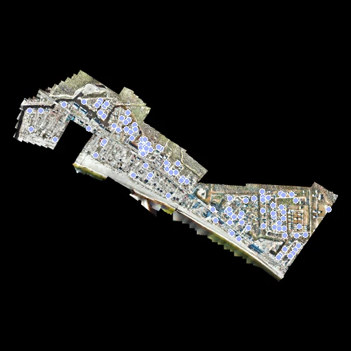
- Test pairs
- 4 test UAS orthomosaics from the provider's test split, Hurricanes Michael and Idalia, then 10 development orthomosaics taken in seed-2026 order among eligible areas of its training split, Hurricane Ian. Each orthomosaic is used once, with its crewed counterpart when available. Test and development share no disaster and no building ID.
- Truth
- landmarks by a program, verified by people Area centroids of matching building_id polygons, translated separately in each source image by the nearest published human building_alignment_adjustment. Only no-damage or minor-damage buildings in both views are eligible. One lexicographically first building is retained per distinct pair of nearest human corrections. Polygon footprints themselves originate from Microsoft or custom author additions, and are not independently traced point landmarks.
- Source
- huggingface.co/datasets/CRASAR/CRASAR-U-DROIDs/tree/c3f5421e1167bb7e88a765e3afa38bebd9898479
arxiv.org/abs/2407.17673
arxiv.org/abs/2405.06593 - Licence
- CC BY 4.0, pinned Hugging Face dataset card
10 pairs for tuning, never tested
1001-Ft-Myers-Beach-Boone, 1001-Ft-Myers-Beach-DIRT, 1001-Harlem-Heights, 1001-McGregor-College-Pkwy-South.3, 1001-Summerlin-San-Carlos, 1002-Ft-Myers-Beach-LCSO, 1002-Ft-Myers-Beach-TFD, 1002-Palm-Acers.1, 1002-Palm-Acers.3, 1002-Palm-Acers.4